Ericsson Tries Tracking Drones Without Network Connections, Launching ISAC Commercialization
TECHWORLD ·
✦ AI Summary
Ericsson unveiled the Ericsson ISAC System, which adds sensing capabilities to existing 5G mobile networks.
The system detects and tracks low-altitude moving objects such as drones, including objects not connected to the network.
Ericsson plans to begin a small-scale commercial pilot for selected customers in 2027 and expand deployment from 2028.
On the 3rd, Ericsson unveiled a technology that detects and tracks low-altitude moving objects using existing 5G mobile networks. The disclosure centered on the Ericsson ISAC System, which applies integrated sensing and communication (ISAC).
The system's core function is to add sensing capabilities to mobile networks. It is designed to focus on detecting and tracking objects even when they are not connected to the network.
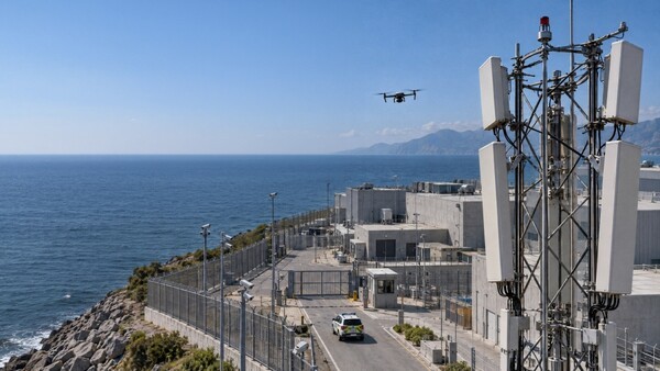
The targets are low-altitude moving objects such as drones. The system is designed to identify the movements of small drones that are difficult to capture with existing surveillance systems. Small drones are characterized by their small size, low altitude, and fast movement.
Ericsson has been conducting ISAC technology trials over the past several months. The company said that in the verification process it confirmed the stable detection and tracking of micro drones at kilometer-scale distances, as well as precise 3D positioning performance.
Ericsson's path to commercialization is gradual. It plans to begin a small-scale commercial sensing-only pilot project for selected customers in 2027. From 2028, it plans to expand the scale of deployment. Integrated communication capabilities are expected to be added during the solution's 6G evolution.
The Ericsson ISAC System uses the reflection characteristics of surrounding objects on mobile network radio signals. Based on analysis of transmit and receive signals from multiple base stations, it identifies an object's presence, location, and movement path. The system applies a multi-static architecture in which multiple base stations geographically separated distribute the transmission and reception of sensing signals. Ericsson said this structure allows the same object to be observed simultaneously from multiple directions. The company also said this approach improves detection reliability, positioning accuracy, tracking continuity, and coverage resilience.
The system combines 5G radio equipment that supports sensing functions with edge computing, AI, and signal processing technologies. It uses towers, backhaul, and spectrum from 5G base stations already deployed in cities, transportation corridors, and strategic hubs as assets. The feature of this approach is that it reduces the burden of building separate dedicated sensor infrastructure by using existing network assets.
The system can share collected tracking data and AI-based classification information with authorized external systems through standardized interfaces. Examples of sharing targets include security systems and command-and-control systems, and sharing is carried out through secure integration methods. It can also be combined with data from other sensors and threat response platforms, supporting a comprehensive understanding of operating conditions and enabling rapid response and decision-making.
Ericsson said the system is not a replacement for existing radar or other sensors but a complementary technology. It explained that actual detection performance is affected by the characteristics of the target object, flight pattern, sensing geometry, terrain and surrounding environment, and system configuration.
Ericsson verified its ISAC technology with Erillisverkot in a real 5G network environment in Helsinki, Finland. In the process, it demonstrated drone detection and tracking using multiple 5G base stations and confirmed that network sensing can expand surveillance coverage in combination with existing sensors. It also confirmed the potential of network sensing to support public safety and Counter-UAS operations.
In Arlington, Texas, the company conducted a joint test with AT&T. In that test, a sensing dashboard displayed multiple drone activities and tracked their locations and movement paths. This confirmed the potential to use telecommunications infrastructure for security and safety management at major venues and critical infrastructure sites.
In Poland, Ericsson, Asseco, and the mobile operator Play collaborated. They combined Ericsson ISAC technology, the Play mobile network, and Asseco's PUSZCZYK acoustic detection system. Through this, they demonstrated ways to improve the accuracy of low-altitude drone detection and positioning.
Ericsson plans to expand the use cases for the ISAC System. The expansion targets include defense, public safety, critical infrastructure, transportation, and industry.
In defense and public safety, the company suggested using the system to strengthen monitoring of airspace around borders, coastlines, and strategic assets. In critical infrastructure, it includes use for protecting key facilities such as ports and power plants. In transportation and industry, it was presented as a way to support safe operations on roads, railways, and industrial sites.
The use of sensing data could lead to wider drone adoption within the low-altitude economy, and its application potential in that sector was also presented. The sensing data could be used for drone traffic management, urban airspace monitoring, smart city planning, and digital twin construction for environmental mapping.
Freddie Södergren, Ericsson's global head of mission-critical networks and defense, said that low-flying drones create blind spots in detection coverage that are difficult to solve with a single sensor alone. He said the Ericsson ISAC System performs wide-area detection and continuous tracking based on cooperation among multiple 5G base stations. He added that the collected data can be integrated with existing sensing technologies and with operational systems.
Freddie Södergren said this structure allows telecom operators to create new services by using existing network assets.
Joe Madden, principal analyst at Mobile Experts, said the Ericsson ISAC System demonstrates the performance of mobile network sensing because it uses complex radio reflection signals to accurately track low-altitude flying objects and can also track objects that do not cooperate with detection. He also said the system has the potential to provide wide-area drone detection capabilities more quickly and cost-effectively than building dedicated sensor infrastructure from scratch, since it leverages an existing, widely deployed base station footprint.
Source: TECHWORLD · Park Gyu-chan
Original: https://www.epnc.co.kr/news/articleView.html?idxno=409178
References
This article was produced with the help of an automated content generation algorithm.
Source: TECHWORLD
View originalThis article was summarized and organized by BizCrush based on the original article from TECHWORLD. For exact quotations and full details, please refer to the original article.